Northeast India flood: Man-made disaster worsened by climate change
Scrap-metal trader MD Alam was sleeping in his riverside cabin along the Teesta River in northeast India on Oct. 4 when he received an urgent phone call.“It seems a dam in Sikkim has breached. A huge flood is coming down,” his friend warned.
The South Lhonak glacial lake in the Himalayan region of northern Sikkim near China and Nepal experienced a sudden and significant overflow last week for reasons still under investigation.
The breach caused a flash flood in the Teesta River, destroying a major dam in Chungthang, 60 kilometers (37 miles) downstream, and affecting parts of Sikkim and West Bengal.
The river water level rose by 8-18 meters, the Central Water Commission said. The 60-meter dam had a capacity equivalent to over 2,000 Olympic pools, but the exact water level at the time is unclear.
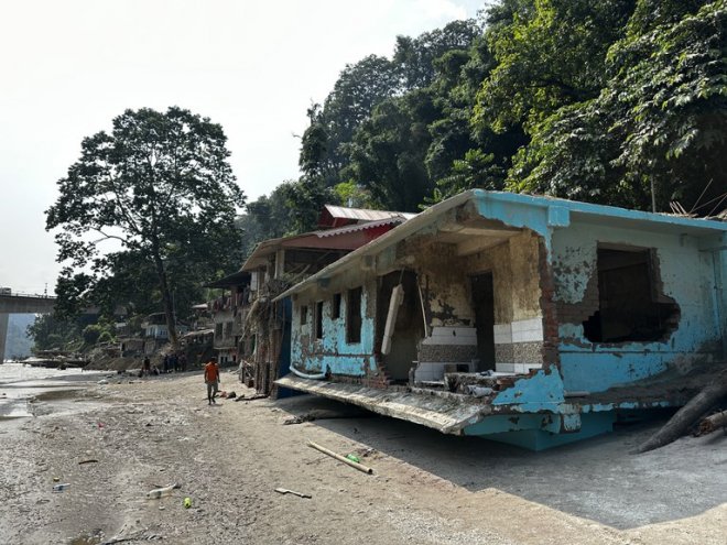
 A badly damaged home by Teesta River after a deadly flood in Teesta Bazaar, West Bengal, India. Oct. 10, 2023. Credit: Subel Rai Bhandari for RFA
Hundreds of houses, roads and bridges were washed away. At least 75 people are confirmed dead, according to Indian authorities, while more than a hundred are still missing. Alam’s family was among those affected.
“I managed to save only my family. I could not take out a single thing,” Alam told Radio Free Asia on Tuesday.
He added that while all 12 of his family members were safe, three of their houses by the river were swept away, along with all their belongings.
A week after the flooding, debris from the surge still littered the roof of his recently constructed two-story house, the only standing building in the vicinity.
“Everything I have worked for and owned was gone within a minute,” the 55-year-old patriarch lamented.
A few minutes later, Alam received a call that his daughter’s father-in-law in another flood-hit village had died.
“I don’t know how to feel or express my feelings. The river increases yearly, but it was something else this time,” he said as he hurried off.
 A man walks past a vehicle covered in sludge after a deadly flood in Teesta Bazaar, West Bengal, India. Oct. 10, 2023. Credit: Subel Rai Bhandari for RFA
Triggered by glacial lake outburst
Originating from the Eastern Himalayan glaciers, the 414-kilometer-long Teesta River meanders through West Bengal and parts of Bangladesh before joining the grand Brahmaputra River.
South Lhonak, at 5,200 meters (17,060 feet), is one of the largest and fastest-growing glacial water reservoirs that feed into the Teesta.
The actual reason for the glacier lake outburst is unknown, but officials suspect the exceptional rainfall or a 6.2 magnitude earthquake that hit neighboring Nepal the preceding Tuesday to be the culprits.
The Sikkim government said this week that “a thorough inquiry by a multidisciplinary team of experts will be initiated by the State government once the situation stabilizes.”
India’s National Disaster Management Authority (NDMA) blamed intense rainfall for the glacial lake outburst flood (GLOF) – which happens when the icy reservoir’s natural barriers are compromised, likely due to the permafrost thaw.
Such breaches can be precipitated by landslides, earthquakes or extreme rainfall, leading to a high-altitude “tsunami.”
 Students from St Augustine School in Kalimpong arriving to distribute relief after a deadly flood in Teesta Bazaar, West Bengal, India. Oct. 10, 2023. Credit: Subel Rai Bhandari for RFA
In recent years, researchers and government officials noted the increasing water levels in South Lhonak due to the melting glaciers caused by global warming, with experts singling it out as “high risk” and “critical.”
Studies have shown South Lhonak increased almost ten times from 17 hectares in 1977 to 167 hectares just before the burst. Last week, the Indian Space Research Organisation (ISRO) released a satellite study saying about 105 hectares of water area was drained out after Oct. 4.
Since the floods, schools and universities have been closed as clean-up and relief operations continue, while land access and mobile connectivity in many areas remain cut off. State-established relief camps now house thousands of affected individuals.
Last year, the most senior science bureaucrat in Sikkim emphasized the need for an early warning system at glacier lakes like South Lhonak, where it was installed in September but was not fully operational when the floods hit.
 Satellite images showing the Himalayan Glacial Lake before and after bursting its banks and triggering flash floods, in South Lhonak Lake, Sikkim, India. Credit: ISRO.
Man-made disaster
Anit Thapa, chief executive of the Gorkhaland Territorial Administration, the highest local authority in West Bengal state, said this was “the first time Teesta has been this disastrous.”
“Many people had literally five seconds to leave their homes,” he told RFA in Teesta Bazaar. “In some areas, whole villages have been washed away … The damages are unsurmountable.”
Apart from dams, there were also encroachment of the riverbeds for roads and settlements, obstructing the water flow, he said, adding the disaster was “human induced.”
“Basically, Teesta River is taking its natural course. We built dams and other infrastructures and changed the natural flow of Teesta. Now it’s claiming it back,” Thapa said.
 Heavy construction vehicles buried under a sludge after a deadly flood in Teesta River, Rongpo, India. Oct. 6, 2023. Credit: Shreya Thapa
Sikkim’s chief minister told Indian media the disaster was due to sub-standard Chungthang dam construction for the 1200-megawatt hydroelectric project.
Locals and experts say the government knows well about the dangers of building hydropower dams in the Himalayan region with tectonic activity, melting glaciers and extreme rain.
In 2021, India’s Department of Water Resources warned of South Lhonak Lake’s threat to hydropower projects, with a 2020 NDMA report highlighting Sikkim as the most at risk.
“This disaster was foreseeable,” said Gyatso Lepcha, the general secretary of the indigenous group, Affected Citizens of Teesta, adding the damage was exacerbated by dam construction.Despite warnings, Sikkim and West Bengal governments continue developing hydropower dams on Teesta, with at least 47 projects in different development stages currently.
Vimal Khawas, a professor at New Delhi-based Jawaharlal Nehru University, said hydropower has played a role in maximizing the disaster.
“Humans have heavily encroached upon the riverbed areas of upper Teesta basin,” he said. “When events like cloud burst, GLOF and dam burst happen, disaster is the only consequence. Even if cloud burst and GLOF are natural, the resultant disaster is 100% human made.”
 Buddhist men helping clean up an affected house after a deadly flood in Teesta Bazaar, West Bengal, India. Oct. 10, 2023. Credit: Subel Rai Bhandari for RFA
GLOF, a severe threat
Between 2000 and 2016, Himalayan glaciers lost about 8 billion tons of ice annually, mainly due to climate change.
Last year, a report from India’s earth sciences ministry said the mean retreat rate of the Hindu Kush Himalayan glaciers was 14.9-15.1 meters per annum, with 20.2-19.7 meters per annum in the Brahmaputra river basins.
According to a report in June from Kathmandu-based International Center for Integrated Mountain Development, Himalayan glaciers could lose 80% of their volume by the end of this century.
“Tragically, the River Teesta is the latest in a series of devastating flash floods we’ve seen this monsoon that shows that the Hindu Kush Himalaya, on which a quarter of humanity relies for freshwater, food and energy, is a region on the brink,” Izabella Koziell, deputy director general of ICIMOD, told RFA on Thursday.
“Climate change is flipping the mountains and glaciers here from being reliable water sources into hotspots of hazard, with glaciers melting at unprecedented rates, snow and rainfall patterns becoming erratic and extreme and permafrost that provides stability to steep mountain slopes thawing.”
 A submerged highway to Darjeeling after a deadly flood in Teesta Bazaar, West Bengal, India. Oct. 10, 2023. Credit: Subel Rai Bhandari for RFA
According to scientists, the mountain regions of Asia are warming at twice the global average.
“GLOF risks are set to rise—and we urgently need to think beyond one lake to ensure every dangerous lake in this region has early warning systems for those downstream,” said Koziell.
“But also, accelerated glacier melt means this region is set to reach ‘peak water’ in 2050. That is just 17 years away. After which water supplies will decline, driving huge uncertainty for communities here.
“It is clear that, as well as these hazards, we now stand on the cusp of systemic disruption to food, water and energy security in one of the most populous regions in the world,” she said.
Edited by Taejun Kang and Elaine Chan.
[圖擷取自網路,如有疑問請私訊]
|
本篇 |
不想錯過? 請追蹤FB專頁! |
| 喜歡這篇嗎?快分享吧! |
相關文章
AsianNewsCast


